Bluewren Photos Suite
Bluewren Partners is a Canberra based collaboration between Robert Bleeker and Geoff Farrar who have developed and continue to evolve the Bluewren Photos Suite. The Suite is currently in use under licence by a number of Canberra clients with a number of exciting new features and developments.
Genus
The seed for the Suite was planted on large rural highway projects in 2000, at the dawn of digital photography where the location and context of pictures was laboriously included in the filename to allow far away designers to appreciate issues at remote sites. Commencing in 2008, the concept has been developed and used on multiple projects and is now a well secured ecosystem of photo recording, viewing and editing tools that is known as the Bluewren Photos Suite.
The Suite has been in a state of constant evolution and improvement since inception and has been designed and developed with direct feedback from “on the ground” users. It has proven to be suitably intuitive and robust to meet the needs of most, including enough features to be highly useful, without being overly complex. It is available on both Apple and Android devices.
…it sure beats having masses of photos in directories created by different users, downloaded (or not), including or missing GPS data, from a range of devices, in SMSs or Emails that are impossible to find just when you really need them….
The five main elements of the Suite
Access and viewing photo records after the licence ends
Captured images are accessible and can be viewed and downloaded at any time through the Photo Viewer during the term of a licence. At the completion of a project / end of a licence or at any time through the Bluewren Manager, all of the photo records can be downloaded either as a PDF report or in electronic format (jpegs with searchable database tables).
The photo records may be downloaded as jpegs through Archiving or an Photo Albulm. Archiving allows download via a link of just the .jpeg files in directories matching the Photo groups without a database. Alternatively a Photo Album can be created and downloaded which includes a special html off-line vieweralong with the database files that contain the classification information. The Photo Album with similar view and search functionality to the on-line Photo Viewer allows for enduring reference and ease of identification of relevant photos without the need for a subscription, or if ongoing external data security may be an issue. This may also be provided to clients and provides the advantage of having all of the photos and associated data resident on your own local / cloud server. The Photo Album uses a html script and runs on any browser as the viewing interface, avoiding any security concerns associated with a .exe program / viewer.
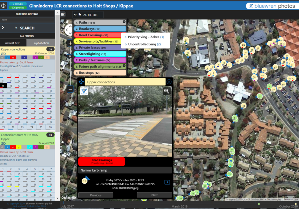
Aggregation of pictures from as many users as desired
An often undervalued advantage of using the Suite is that photo records can be captured by as many users as authorised and aggregated in to a contiguous searchable pool of photo records known as a Photo map. Images may be captured and and uploaded by multiple users simultaneously. The combined photo records are then available for reference and filtering / search immediately, and into the future using a classification system tailored to the requirements of the user or project. For example a Contractor in the field may take pictures for a Client in their office to allow works verification or assist in resolving a site issue without the need to visit a remote site.
Proven track record
The evolution of the Suite has been continuous with a major update of the Photo Record Tool functionality and “look and feel” in late 2022 and further changes and from user feedback in late 2023 including updates to user guides. The Suite has been utilised on a multitude of projects since its inception including construction surveillance on roads, subdivisions. wetlands, services installations and hard and soft landscaping. Also for photo recording to assist in the design of signage installations, intersection upgrades, feasibility studies and existing condition surveys to provide an enduring reference of the dilapidation of existing assets.
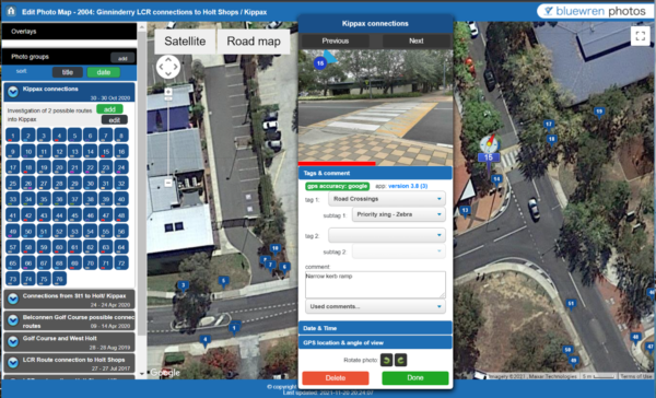
The Suite has also been utilised to document the progress of building works and verification of work quality remotely during Covid. A floor plan can be included as an overlay to locate the photo records along with the angle of view, selected tags and included comments to provide easy appreciation of a situation from the photo context.
Benefits of use over other products
The many benefits available from using the Suite on any project are real and include:
For All
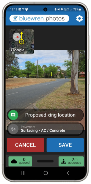
- Photo records captured using most phones and tablets with the Photo Record Tool available for download in Android and Apple IOS versions
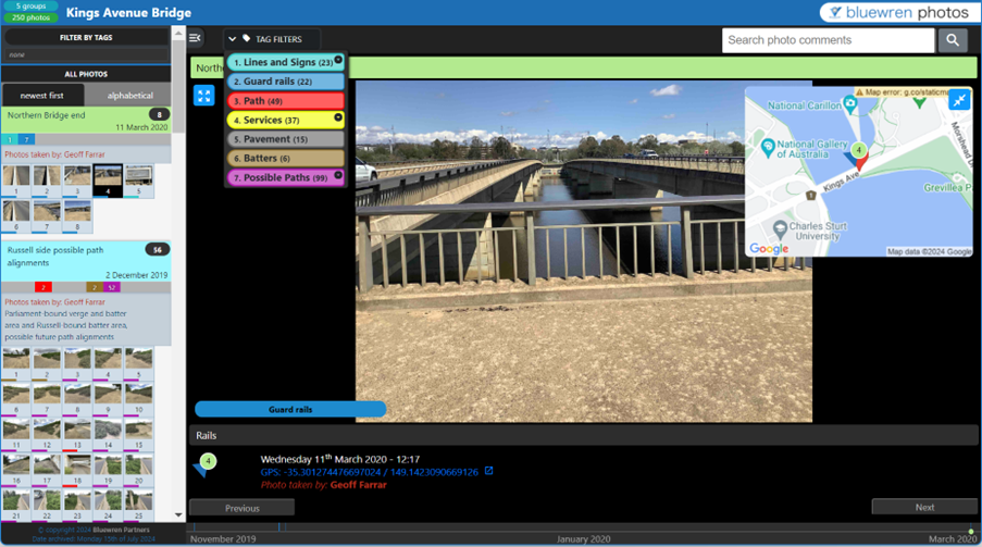
- Filtering by tag and subtag and search through spatial radius from a point, time and any key word or phrase in comments to allow timely identification of images that may assist in resolving an issue including forensic review.
For Clients
- Photo recording and information captured by in-house and/or third party users for immediate viewing and future reference in an aggregated pool or Photo map
- A single repository for photo records that may be captured by and made accessible to the whole team
- Appreciation of existing site conditions remotely with overlays of proposed works or floor plans to better appreciate the context of the situation
- Surveillance of a work site by others in near real time with searchable records associated with images so they can be easily found if needed in future or other remote team members
- Readily available store of images for reporting and promotion
- Understanding of complex situations from targeted photos
- Construction or insurance claim assessments and review including delay and prolongation cost claims
- Appreciation of where issues exist from site audits (Safety, environmental or quality) and how and when issues have been closed out. This includes ease of identification of similar issues that have occurred previously in the same area.
For Contractors
- Appreciation of site conditions and works in progress at any given time through the project
- Record of plant and personnel on site
- Photos with appropriate comments to support “Requests for Information”, variations and progress claims
For Consultants
- Establish position relative to planned infrastructure using overlays of plans on greenfields sites
- Remote sharing of photo information for collaborative design
- Photos can be taken by the whole team including sub-consultants and stored in the one place under a unified classification system for reference through the design process
- Viewing access may be secured through a PIN if controlled access is required
- Comparison of asset condition for dilapidation surveys or handover of assets and defect repair monitoring and close out without the need for full group inspections
- Enduring record of site conditions to a user defined classification system for future image identification and ongoing reference